Overview
Chama is an open source Python package which includes sensor placement optimization methods for a wide range of applications. Some of the methods in Chama were originally developed by Sandia National Laboratories and the U.S. Environmental Protection Agency to design sensor networks to detect contamination in water distribution systems [BHPU06] [USEPA12] [USEPA15]. In this context, contamination scenarios are precomputed using a water distribution system model, feasible sensor locations and thresholds are defined, and the optimization method selects a set of sensors to minimize a given objective.
Chama was developed to be a general purpose sensor placement optimization software tool. The software includes mixed-integer linear programming formulations to determine sensor locations and technology that maximize monitoring effectiveness. The optimization formulations in Chama can be used to minimize impact or maximize coverage. Chama includes functionality to define point and camera sensors that can be stationary or mobile. Furthermore, third party system models can be integrated into the software to determine sensor placement for a wide range of applications. The software is intended to be used by regulatory agencies, industry, and the research community. Example applications are included in Figure 1.
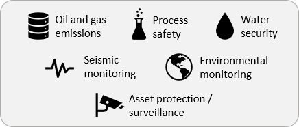
Figure 1 Example sensor placement applications
For each application, an appropriate model must be selected to represent the system. For example, atmospheric dispersion models can be used to place sensors to monitor oil and gas emissions, while water distribution system models can be used to place sensors to monitor drinking water quality.
The basic steps required for sensor placement optimization using Chama are shown in Figure 2.
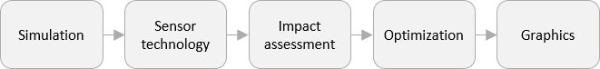
Figure 2 Basic steps in sensor placement optimization using Chama
Simulation: Generate an ensemble of simulations representative of the system in which sensors will be deployed.
Sensor technology: Define a set of feasible sensor technologies, including stationary and mobile sensors, point detectors and cameras.
Impact assessment: Extract the impact of detecting each simulation given a set of sensor technologies.
Optimization: Optimize sensor location and type given a sensor budget.
Graphics: Generate maps of the site that include the optimal sensor layout and information about scenarios that were and were not detected.
The user can enter the workflow at any stage. For example, if the impact assessment was determined using other methods, Chama can still be used to optimize sensor placement. The following documentation includes additional information on these steps, along with installation instructions, software application programming interface (API), and software license. It is assumed that the reader is familiar with the Python Programming Language. References are included for additional background on software components.